Planning to do the Dragon’s Back Hike Hong Kong? This iconic trail is one of the most scenic hikes in the city, with panoramic views of the South China Sea, lush greenery, and a smooth path perfect for beginners.
Whether you’re looking for trail tips, how to get there, or what to expect, this guide to the Dragon’s Back Hike covers it all.
This beginner-friendly hike offers panoramic views of the South China Sea, making it one of Hong Kong’s most scenic trails. Prepare for an unforgettable adventure on the best hiking route in Hong Kong!
Dragon’s Back Hike – Hong Kong’s Most Scenic Trail with Epic Views
The Dragon’s Back Hike Hong Kong is often considered one of the best nature escapes on the island. The hike, which is almost 12 km long, starts at the top and ends in the city.
The view is impressive, a mix of nature with rocks and cliffs.
The route is easy to navigate, and the paths are well-marked. It is considered an “easy” walk without significant dangers or the risk of getting lost.
If you have a few days in Hong Kong and like nature, I recommend this walk. There are many options in Hong Kong, and it can be difficult to choose.
Map: where do we start?
On the map above in “Details,” you can download the route in KML or GPX and use it in Maps.me or another application.
You can use it without the Internet while you walk.
How to get there?
Dragon’s Back is a popular hiking trail in Shek O National Park, located south of Hong Kong Island.
To get there, take the subway to the MTR Shau Kei Wan Station, then take the (mini) bus number 9 outside the subway.
Get off at the To Tei Wan bus stop that drops you off at the entrance to Dragon’s Back. The walk ends at Chai Wai subway station.
The bus we took was small, and many people left at that point to begin walking.
The driver was amiable, even waiting for us to grab our morning coffee at the 7-Eleven across the street. It’s worth noting that there’s a bakery next to the subway if you need a quick breakfast.
Check the MTR website for updated schedules.
- For seamless travel, equip yourself with the Octopus card, your key to hassle-free metro and bus trips.
- If you’re planning the Dragon’s Back Hike Hong Kong, don’t forget to bring water.
- In summer, wear a cap or hat to protect yourself from the sun, as many areas along the route lack shade.
- In summer, it is better to go early to avoid the heat.
- There are bathrooms at the beginning and almost at the end of the park.
- The walk lasts 3 to 4 hours, depending on how much you stop to take photos, eat a snack, and enjoy the views.
Start of the hike
Our experience was excellent from start to finish.
Our visit in late February was blessed with sunny weather and a comfortable 18°C temperature, creating a serene atmosphere with few people at the bus stop and on the route.
During the tour, we found some groups, young and older people, enjoying nature and waving as they passed. There was a good atmosphere. Seeing how people came and went while appreciating nature, relaxing, and socializing during the walk was nice.
The walk begins with a path with stairs and impressive views of Tai Tam Bay and the Stanley Peninsula.
First Viewpoint on Dragon’s Back Hike Hong Kong

After walking approximately 1.5 km, we arrived at the first viewpoint overlooking a cliff. It was our first time in Hong Kong, and the view was beautiful. Seeing the city and the contrast of the blue waters that disappeared into the horizon was not precisely what I expected from Hong Kong.
Along the route

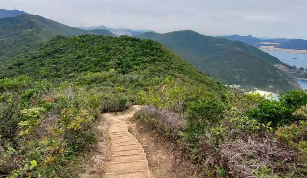
Once we left the first viewpoint, we immersed ourselves in the descent along the ridge, entering the dragon’s back.
The trail unfolds over the ridge, accompanying us for a considerable stretch.
From time to time, a new viewpoint, each more surprising than the last, unfolds before us. Although the view accompanying us seems to remain unchanged throughout our journey, we finally reach a point where we will begin the descent.
The contrast of the vegetation with trees and bushes and, in the background, the deep blue of the vast Pacific Ocean is lovely.
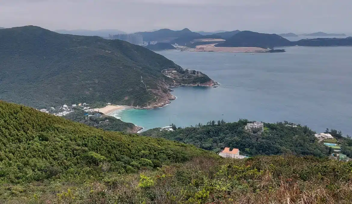
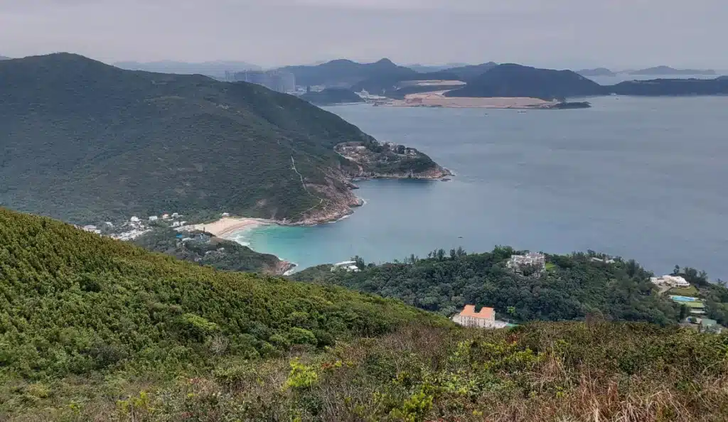
Dragon’s Back Hike – Panoramic Views Over Shek O Peninsula

As you continue, you will come to a junction with a small rest area and a few signs. Follow the “Dragon’s Back” sign at the top of the stairs.
Keep going, don’t give up! The view will be worth all your effort when you reach the point with the unique rock formations and a breathtaking panoramic view of the Shek O peninsula.
Path to Pottinger Peak
At this point, you can continue towards Big Wave Bay.
The spectacular views cease briefly; the panorama changes as you find yourself inside the forest.
I suggest you continue towards Big Wave Bay or Pottinger Peak as we did.

Dragon Back Hike
Pottinger Peak

Dragon Back Hike
The peak is named after Henry Pottinger, the first governor of Hong Kong during the British colonial era in the 19th century.
From the top of Pottinger Peak, the panoramic views of Hong Kong Island are spectacular.
In the photo, you can see the typical skyscrapers and, to the right, an immense cemetery, “Cape Collinson Chinese Permanent Cemetery.”
In Hong Kong, embarking on this hiking route is not just a journey; it’s a unique and privileged experience.
Descent to the metro station

Dragon Back Hike
In our case, the time has come to head to the subway station to return to our hotel in Wan Chai.
We will pass a sign that says “Chan Wan via Cape Collinson Road” and take that route.

How to End the Dragon’s Back Hike Hong Kong – Route to MTR Station
We were surprised by a pedestrian crossing with escalators at a certain point.
The crossing looked new, saving us time and shortening the distance.
Instead of taking the long route, we opted for a direct, shaded path. Our weary legs were immensely grateful for this thoughtful shortcut.
Upon reaching the bottom, it’s just a few minutes’ walk to Chan Wai subway station.

Upon reaching the bottom, it’s just a few minutes’ walk to Chan Wai subway station.
This is the end of the trail! Hopefully, this article will help you plan your Hong Kong visit and hiking route.
Love hiking? Check out my guide to Lion Rock Hike in Hong Kong for another incredible trail!
Is it easy to navigate?
It was undoubtedly an easy journey; we saw many older adults.
The only things to consider are the stairs and the steep path in sections.
I saw some people doing acrobatics on rocks and next to cliffs.
It’s not worth risking my life for a selfie.
In general, the path is well-marked and safe throughout the route.
Who would you recommend this hike to?
This hike is for nature lovers and those who want to get out of the city of Hong Kong.
It is one of the most popular hiking routes as it is easy to access and offers stunning views.
Can you go to the beach?
The walk ends near Big Wave Bay, a picturesque beach famous for its surf-friendly waves.
After the hike, you can relax in the sand, swim in the summer, or even try surfing.
What is the length and duration of this route?
The walk is approximately 12 km.
The average duration to complete the trail is 3 to 4 hours.
It depends on your pace and the time you spend admiring the views.
Whether it’s your first time in the city or you’re a seasoned hiker, the Dragon’s Back Hike Hong Kong is an unmissable trail.
If you enjoy scenic trails, don’t miss Hiking in South Korea and visiting The Charming City of Gyeongju.
Pin this post